
Walk a Crystal Lake Street
A sound street-by-street search follows the address through several kinds of evidence. Start with the county tax system because it can turn a house number into a parcel identification number, or PIN. The result separates the physical property location from the name and address used for tax mail. That difference prevents a remote mailing address, trust, or business from being mistaken for a household.
Move from the parcel to the recorded deed and map. Use current voter registration only to confirm a person and address already supplied, not to create a street roster. For an older household, reverse directories and phone books can place a listed name at an address in a publication year.
- Normalize the house number, directional, street suffix, postal city, and likely municipality.
- Search the McHenry County Property Tax Inquiry by address range. Copy the PIN, situs, legal description, and tax year.
- Open the parcel in Athena GIS. Check its polygon, subdivision, nearby parcels, and district layers.
- Search the Recorder Free Web Search by PIN and party. Match the legal description before accepting a deed.
- Confirm a supplied voter and address through the state form, or use the library's reverse directories for an older association.
Each step answers a different question. The tax result names a taxpayer, the deed names parties to a transfer, and a directory records a published address association. Keep those roles separate.
Search Crystal Lake Address Ranges
DEVNET wEdge is the clearest tool for browsing by street. Its address mode accepts a low and high house number, a street name, and a city. That range can expose candidate parcels along one segment. The city field is a search term, not proof that every result sits inside Crystal Lake's legal boundary. Compare the situs and tax districts with Athena or the official city map.
| Search mode | Visible fields | Best street use |
|---|---|---|
| Basic | PIN or owner name | Return to a known parcel or taxpayer |
| Address | House Number Low/High, Street Name, City | Browse a short street segment |
| Sales | Price and sale-date ranges | Find sales leads before checking deeds |
| Advanced | Class, township, tax district, tax years | Separate local jurisdictions |
| Mobile Home | Home number, owner, house number, street, city | Use the distinct mobile-home index |
The portal labels its live data by tax year and update time. Preserve both. An older bill may remain reachable, but no complete published range for assessment history was found.
The Crystal Lake street directory tax search is shown below. Its separate modes explain why a street range should be run in Address Search, then checked against the parcel page.
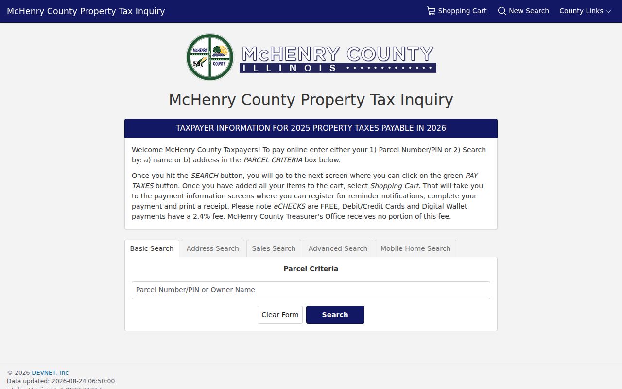
The screenshot also shows that owner and address are alternative starting points. Neither field alone proves who occupies the property.
Read Crystal Lake Street Labels
A tax bill contains several address-like fields that serve different roles. Property Location is the situs, meaning the physical parcel address. Mail To is the destination for tax correspondence. Assessed To names the taxpayer of record. A legal description identifies the land through lot, block, tract, or another recorded description, while the PIN supplies a compact county key.
- Parcel
- A defined piece of land represented by a county PIN and map polygon.
- Situs address
- The physical location assigned to the property, distinct from the tax mailing address.
- Plat
- A recorded map showing subdivision lots, blocks, dimensions, easements, and street layout.
- Criss-cross directory
- A printed reverse directory arranged by address so a reader can find the listed name there.
The bill can also show township, property class, exemptions, taxing bodies, and payment status. Those fields help route a search, but they do not name every person at the address. Phrase the finding as the county lists it.
Map Crystal Lake Street Parcels
Athena adds the map context that a tax-result list lacks. Its stated search modes include Parcel, Subdivision, Address, Owner, and Sales. Property Info opens the selected parcel, while Buffer can define an area around it. Measure, Tri-View, Markup, and Export CSV support close inspection. Layers cover parcel text, sales, subdivisions, flood zones, wetlands, soils, watersheds, fire districts, and several years of topography.
Use the Athena Public Property Search Viewer to see how the Crystal Lake street directory links an address to a mapped polygon.
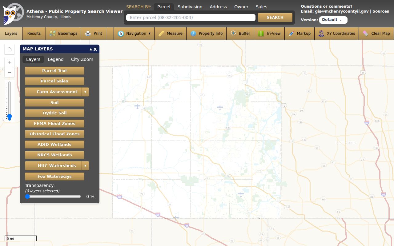
The map is strongest for parcel and district facts. Its owner link still reflects assessment data, not a private household list.
For a block table, retain the street segment, PIN, situs, subdivision, tax district, and source date. Then verify ownership with the recorded instrument. Adjacent polygons are parcel neighbors, not proof that people in those parcels share a household or civic group.
Crystal Lake Street Record Coverage
No single street directory contains the whole record chain. McHenry County and Crystal Lake split address evidence across parcel, deed, map, permit, historical, and voter systems. The table keeps the result type visible so a name is not given more weight than its source supports.
| Address source | Custodian | Street evidence | Access |
|---|---|---|---|
| Tax and assessment | McHenry County | PIN, situs, taxpayer, mailing address, legal description, districts | Free wEdge portal |
| Parcel map | County GIS | Polygon, subdivision, adjacent parcels, mapped layers | Free Athena viewer |
| Recorded land documents | County Recorder | Parties, instrument, date, number, legal description | Free index; paid image routes and office copies |
| City permit or case | Crystal Lake Community Development | Address, record type, status, permit or inspection trail | Anonymous basic ezAPP search; FOIA fallback |
| Reverse directories | Crystal Lake Public Library | Published name at an address for a volume year | Local-history collection; exact Haines run must be checked |
| Voter confirmation | Illinois State Board of Elections | One supplied person and address combination | Free two-step lookup; no street roster |
When a portal does not reveal the needed record, use its custodian. The Recorder offers a counter and copy routes. City files can be requested by a precise address, date range, and record type under the Illinois Freedom of Information Act.
Follow Crystal Lake Deeds by PIN
The Recorder's index is party-based, so a street-wide study must proceed parcel by parcel. Begin with the current tax result. Search the named owner as grantee, then confirm the acquisition deed by PIN and legal description. Read its grantor, recording number, date, and any related instrument. Search that grantor as an earlier grantee to move back one transfer.
The free AVA deed index supports name, PIN, address, and document-type routes. This official screen shows the free starting point for Crystal Lake street records.
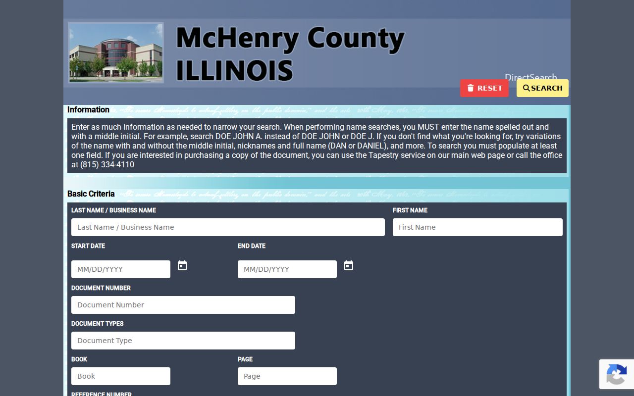
Copy the document number from the result. It is the cleanest bridge to an image or office copy when names repeat.
The Recorder also documents Tapestry Eon for pay-as-you-go access and Laredo for subscribers. Laredo adds party, document number, date, type, parcel, subdivision, tract, address, and associated-document filters.
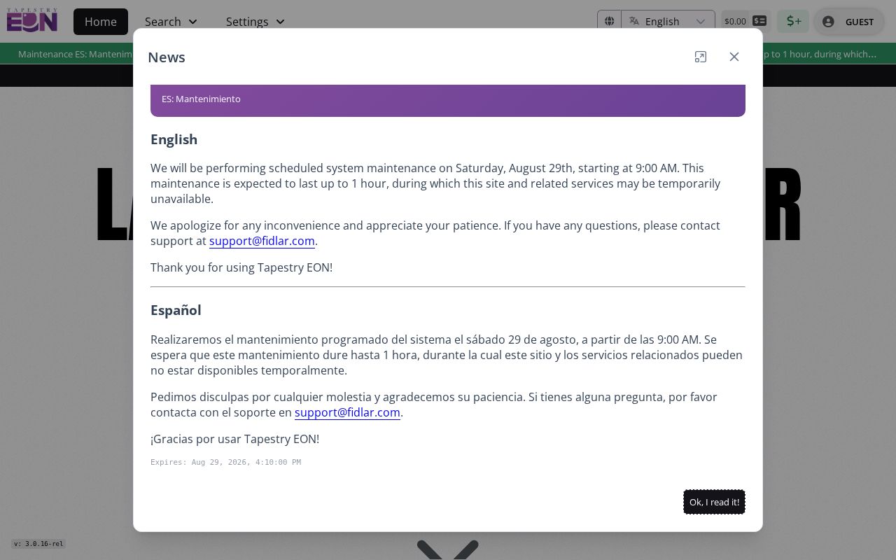
The paid route may help with images and deeper filters, while the free index remains the first check. Confirm current charges before ordering.
Crystal Lake Deeds Reach 1839
McHenry County states that its land-record index and images run from 1839 through the current effective search date. That depth is unusual for an online county trail. A backfile conversion completed in 2012 made roughly 174 of 177 years of information and images searchable at that stage. Older handwriting, image quality, splits, and combined parcels can still force a counter or microfilm check.
This is a records story as well as a search advantage. The county's original Commissioners' Court Minutes volume, covering 1837 to 1848, resurfaced in 2010 after years away. It held decisions about roads, taxes, precincts, and the county seat. A missing online result may have a physical archive history, so ask Records Management, the Recorder, or the library before calling the record nonexistent.
Note: Preserve the legal description at every deed step because a stable street label is less reliable when parcels split, combine, or change names.
Check Crystal Lake Work by Address
Crystal Lake's ezAPP adds municipal evidence to the county parcel chain. Anonymous users can run basic searches across Building, Fire, Planning, Enforcement, and Licenses. A record may show an address, type, status, application, or inspection history. Registration is required to submit an application, request an inspection, or report a code issue.
The Crystal Lake ezAPP portal shows the tabs available for an address-keyed search.
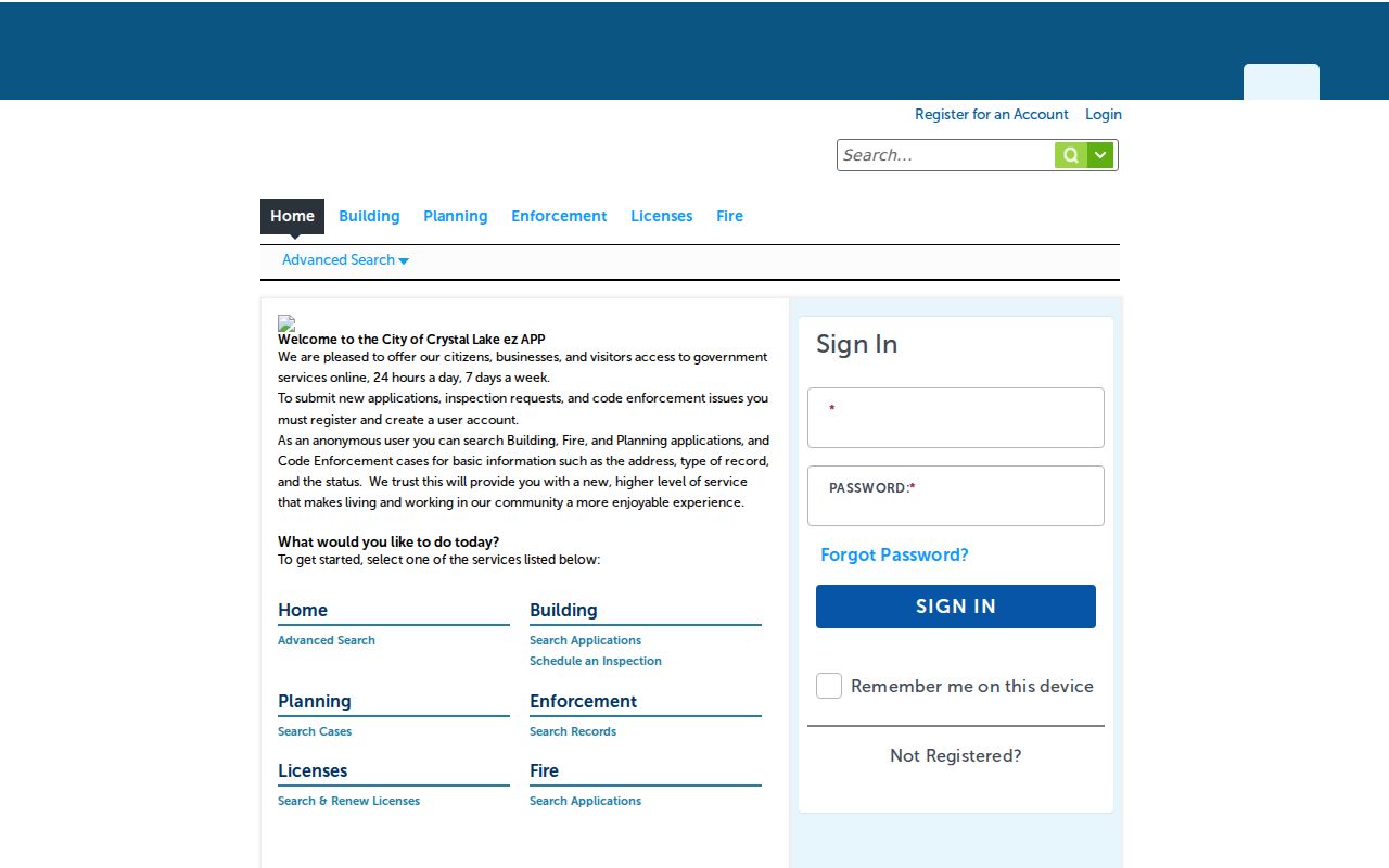
A permit can date work on a roof, deck, pool, HVAC system, driveway, or shed. The applicant or contractor is not necessarily the owner or occupant.
If a file is missing online, ask Community Development or City FOIA for the address, date range, and record category. A Crystal Lake postal address outside city limits may instead belong with County Planning and Development.
Search Crystal Lake's Older Names
Historical street work needs place-name variants. Crystal Lake and Nunda incorporated separately in 1874. Nunda became North Crystal Lake in 1908, then joined Crystal Lake in 1914. An old deed, newspaper, map, or directory may use any of those names even when the present parcel falls within one city.
Library map files cover Crystal Lake city maps from 1915 through 2012, while county atlases include 1862, 1872, 1892, and 1908 editions. Sanborn fire-insurance maps document several dates from 1893 through 1936, with older collection notes also naming 1905 and 1955. Search the Historical Society's street subjects, including Beardsley, Brink, Gates, Paddock, Peterson, Pomeroy, and Walkup, as local history terms.
The library's Haines/Criss-Cross range has a documented conflict. Its current page says 1977 forward, while an older inventory begins in 1984. Call 815-459-1687 to confirm the exact volume and any gap. Historical phone books have conservative documented runs of 1931 to 1959 and 1980 to 2010. The Crystal Lake city directory collections give the fuller shelf context.
Check Crystal Lake Street Geography
Postal and municipal lines overlap but are not identical. ZIP codes 60012 and 60014 serve standard Crystal Lake street delivery and can extend beyond the city. ZIP 60039 is oriented to post-office boxes and should not be treated as a parcel zone. A complete address should be checked through the USPS lookup before its city field is used in wEdge.
A tax bill may reveal the township, school, park, library, fire, and other taxing bodies behind an address. Athena adds mapped fire, flood, wetland, and subdivision layers. Together they can show why a Crystal Lake postal label belongs to Lakewood or an unincorporated area for permit and records purposes.
Crystal Lake Street Search Limits
A street directory cannot establish a complete household. A tax roll can omit non-owner occupants. A deed records parties to an instrument, not every resident. A phone book may list only one subscriber, and a permit may identify an applicant or contractor. The Illinois voter form confirms only a supplied identity and address, while protected records and full voter files are not open as a public block list.
DMV addresses are restricted by federal law. Utility customer details, private association membership, juvenile information, sealed cases, and restricted vital records also stay outside a public by-address search. A missing name can reflect the source's purpose or a legal protection. It is not evidence that the person does not live there.
Lawful use. Crystal Lake address records may support family research, property review, and civic questions. Never use them to stalk, harass, threaten, or harm anyone.
Keep the source date and the exact role beside every name. If a public record appears wrong, contact the office that created it with the PIN, document number, URL, and retrieval date. Do not merge two people because their names and city match.